
Walk South St. Paul Street Records
Use one South St. Paul address as the anchor, not a loose name. The county’s property layer is the best present-day starting point because it joins the situs address to a parcel ID, municipality, map position, and legal-description context. From there, the parcel can lead to recorded instruments, permits, historic street entries, and address-to-precinct geography. Each source answers a narrower question. A property result can identify a parcel, while a deed records an instrument and a directory records a listed person or household at a particular time.
- Check the official South St. Paul street map for the printed street spelling, city boundary, and nearby streets.
- Search the exact address in Dakota County Property Information and save the parcel ID, situs address, legal-description clue, and search date.
- Open the county GIS layers to record adjacent parcel IDs, street context, aerial imagery, or other mapped conditions without assigning occupants from polygons.
- Use the city ePermit route for current address-linked permit records, then use the recorder index for dated deeds and other land instruments.
- For an older household trail, compare the address with the year-specific street section and name section in regional directories.
That sequence gives a street directory search a defensible order. It also avoids a common mistake: treating the owner, a mortgage party, a permit applicant, and an occupant as interchangeable people. They are not. Note: Retain the address, parcel ID, source date, and record type together so later checks do not merge separate parcels or years.
South St. Paul Address and Parcel Search
Dakota County Property Information documents two public starting fields: street address and parcel ID. It does not document a public owner-name search. Start with the full house number and street, then compare the returned street number, street name, municipality, ZIP, parcel ID, and legal description before moving to a second source. The recorded mailing address may differ from the situs address, which is the physical property location shown for the parcel.
| South St. Paul field | How the county presents it | Careful use |
|---|---|---|
| Street address | Address text with suggestions | Begin with house number and street; preserve direction and street type. |
| Parcel ID or PIN | Parcel ID text | Use it as the steadier bridge among map, tax, and deed records. |
| Owner name | Not identified as a public search mode | Do not expect an owner-name search on this public page. |
| Layers and legend | Map controls | Separate parcels from aerial, road, park, contour, and floodplain context. |
| Print property card | County-described output action | Keep the parcel ID and access date with any card or printout. |
A parcel is the county’s unit of land identification. The same street directory work becomes more reliable once it has that stable reference, especially where an older directory uses a street name without a house number.
- Parcel
- A defined piece of land in county mapping and tax records, usually identified by a parcel ID or PIN.
- Situs address
- The physical address assigned to the property. It can differ from an owner’s mailing address.
- Legal description
- The formal land description used in recorded documents. It is often the better bridge when an address changes or is incomplete.
- Plat
- A recorded map that lays out lots, blocks, and streets. DCHS holds plat-map material for historical ownership context.
South St. Paul Street Grid Checks
The 2022 official map shows South St. Paul’s named roads and numbered streets, including Concord, Marie, Southview, and numbered avenues and streets. Read that map before assuming a similar address belongs inside the city boundary. The city maps page also directs users to zoning, future-land-use, and Dakota County GIS resources. Those tools provide geography, not a household roster.
Historic terms can help with document and newspaper searches. The city’s historical analysis identifies North End, South Park, Central, Roosevelt, South End, Messer Street Flats, and Oak Park as older neighborhood areas. Use those phrases as period search terms, not as present-day official boundaries. No official source verified a citywide street-renumbering date, so an unexplained difference in an old street number should remain a research question rather than a guessed conversion.
Street-Search Records in South St. Paul
Several South St. Paul record systems can be entered by address, but their output is not the same. The coverage below keeps the address angle clear. Dakota County owns the parcel and recorded-land layer; the city owns permit files; libraries and historical organizations hold older directory and plat material. A street directory result is strongest when its source and date are stated beside the name or property. The street directory method keeps those date-specific layers from being treated as one roster.
| Address-keyed source | Custodian | What it can show | Access route |
|---|---|---|---|
| Property Information | Dakota County | Parcel ID, situs, map, property card, tax and valuation context | Public online address or parcel-ID search |
| Interactive GIS and Map Catalog | Dakota County GIS | Parcel geography, adjacent parcels, aerials, roads, parks, and other layers | Online; public terminals and GIS help at Western Service Center |
| RecordEASE land index | Property Taxation & Records | Abstract/Torrens index status and recorded-instrument trail | Account/login, copy request, Hastings office |
| ePermit and earlier permits | South St. Paul Community Development | Current permit lookup by number or property address; older request trail | ePermit; request for records before 2014 |
| Street indexes and plats | SPPL and Dakota County Historical Society | Historic address, listed household, lot, and ownership context | Digital, microfilm, library, museum, or research request |
The Dakota County polling-place tool adds only precinct and polling-place geography for an address. It is not a person search. Minnesota voter-list data follows a controlled request process under Minn. Stat. §201.091, and the requested data may be used only for the permitted purposes stated by the state.
South St. Paul Address Permit Files
Current city permits can add a dated address trail when the work category fits the property. The South St. Paul Permits page links to ePermit, where a free account is required and the documented search path accepts a permit number or property address. Listed categories include exterior work, electrical, HVAC, plumbing, and sewer or water work. A map point may help locate the file, but it is not a finding that a named person lived at the property.
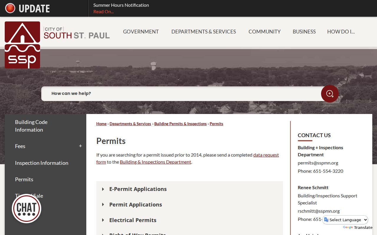
The permit page shown above separates the current online route from the older-record request route. Permits before 2014 require the completed data-request process through permits@sspmn.org, 651-554-3220, or City Hall at 125 Third Avenue North, South St. Paul, MN 55075. Dakota County’s One Stop system handles county-controlled right-of-way permits and requires the exact address, which is a separate jurisdictional path.
Use the permit type and date to describe only what the record supports. A reroofing record, for example, may place work at an address without establishing the occupant list for that date. Note: A missing ePermit result does not rule out a parcel record, an earlier permit, or a request-only city file.
Dakota Deeds Behind South St. Paul Streets
RecordEASE is Dakota County’s recorder index and document route. It requires an account for the full portal. At inspection, the county identified Abstract Computer Index and Torrens Computer Index postings through August 25, 2026, while Abstract documents indexed were identified back to July 8, 1993. The county did not publish an exact Torrens starting date. Older or missing material may therefore need office research instead of an assumption that the online index is complete.
Use the parcel ID and legal description to locate the appropriate land trail, then read party roles with care. A grantor transfers an interest; a grantee receives one. A mortgage party, lien claimant, trustee, attorney, or document preparer is not automatically an owner or occupant. For an important hit, Dakota County offers ordinary copies at $1 per page and certified copies at $10. Written copy requests go to Property Taxation & Records, Attn: Research, 1590 Highway 55, Hastings, MN 55033; the county states a 24-hour turnaround for mailed requests and asks researchers to confirm page count first.
South St. Paul’s 1929 Street Index
Historical street work needs the right edition, not a modern assumption applied to every year. Saint Paul Public Library reports that the 1879 directory added a street index with “to/from” directions and that house numbers were added in 1885. The 1929 volume is especially useful for South St. Paul: it has a separate South St. Paul street index, a pink street index, wives’ names, and a dotted circle marking a homeowner. South St. Paul residents also appear in the St. Paul white pages.
Later conventions change again. The 1933 directory lists all adults, the 1940 book uses a telephone indicator without a number, the 1961 street index adds phone numbers, and 1964 has a separate telephone section. Record the edition, page, section, printed street spelling, number, and whether the hit came from a name or street index. For the full collection and how to read its entries, use the South St. Paul directory book rather than treating one reverse listing as a complete household history.
South St. Paul Streets at Postal Edges
ZIP 55075 is the primary South St. Paul mailing ZIP shown on Dakota County’s map, but nearby labels include 55076, 55107, and 55118. Postal geography does not redraw municipal boundaries. When a street directory search reaches an edge address, use the USPS ZIP Code Lookup for the address-level mailing result, then compare it with the city street map and the parcel’s municipality.
Keep directional letters, street type, unit text, and any returned ZIP+4 exactly as printed. ZIP+4 improves delivery precision; it is not a property or resident identifier. This small geography check can prevent a similar street name in South St. Paul, St. Paul, or West St. Paul from being folded into one record trail.
South St. Paul Precincts by Address
Dakota County Find My Polling Place accepts an address and returns precinct and polling-place information. It is useful when the street record needs current election geography, but it does not return a public household-name list. The county identifies South St. Paul P-5 as having Spanish-language minority-language materials under Minn. Stat. §204B.295, a detail specific to that precinct rather than a citywide statement.
For questions about precinct records or the controlled voter-list request process, Dakota County Elections can be reached at 651-438-4305 or elections@co.dakota.mn.us. Keep precinct context separate from a property trail and respect the state’s certified-use limits for voter data.
South St. Paul Street Research Offline
When the online path stops, the fallback is specific. Dakota County’s Western Service Center in Apple Valley has two public Property Information terminals in its main atrium, plus GIS help on the third floor. Public GIS hours are 8:00 a.m. to 4:30 p.m. Monday through Friday except federal holidays; map printing questions go to 952-891-7081 or GIS@co.dakota.mn.us. The GIS office can also provide custom mapping, while county map printing has listed size-based charges.
For historic South St. Paul streets, the Lawshe Memorial Museum holds 1879-present plat-map ownership material, city directories, telephone books, census resources, and newspaper microfilm. Its research library is at 130 3rd Avenue North, South St. Paul, and encourages a call to 651-552-7548 before visiting. Saint Paul Public Library, the Dakota County Historical Society, and the Minnesota Historical Society supply additional microfilm, directory, newspaper, and archival routes. A street directory search can continue there when an online address tool ends. No distinct South St. Paul Sanborn sheet set was verified, so a St. Paul Sanborn volume should not be assumed to cover a South St. Paul address.
Limits of South St. Paul Street Searches
A street directory does not create a complete live list for a road. Parcel maps show land geography; recorded deeds show an instrument and named parties; permits document a city file; directories place listed people at a date. A vacant parcel, a shared building, a mailing address, or a protected record can make those sources diverge. Minnesota Safe at Home participants receive a substitute address and confidential voter treatment, and other court or statutory protections can limit public results.
For a missing or older record, ask the custodian for the correct request path or use the library and archive trail that matches the period. A no-result from one source is not proof that no earlier household, instrument, or address form exists.
Lawful use. South St. Paul street records support personal property, family-history, and civic research. Minnesota law prohibits using information to stalk, harass, or harm another person.